The first week of school can be intimidating for any student. Waking up on time, meeting new people, navigating between classes on an unfamiliar campus -- it’s enough to make some people stick to online courses. But navigating campus poses an added challenge for students with visual impairments, who don’t have the convenience of conventional maps to help guide their way around. Instead, they often work with an instructor prior to their first day of class to get their path down pat.
Howard Kaplan thinks there may be a better way. For the past three years, the visualization specialist at the University of South Florida
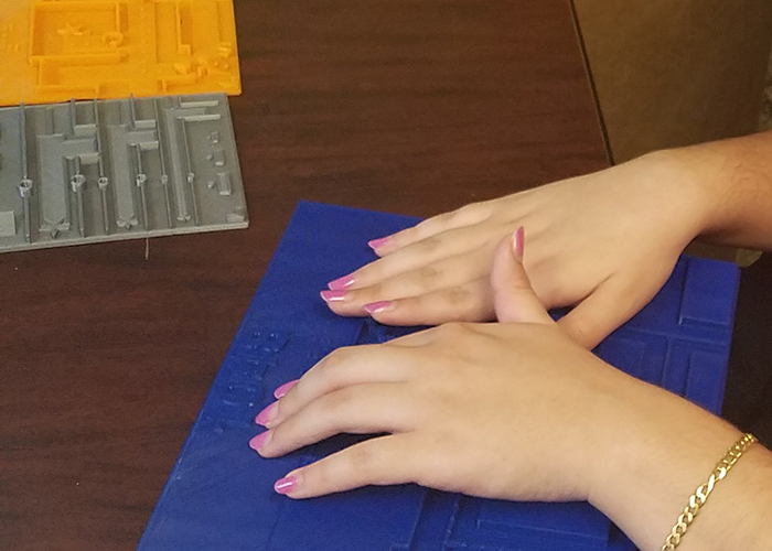
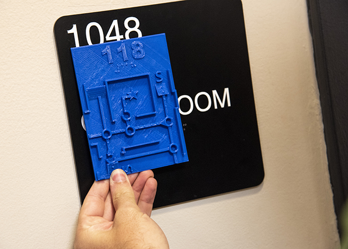
Advanced Visualization Center (AVC) has been designing tactile maps to help blind and visually impaired students get around easier. Much like conventional maps, tactile maps feature prominent objects and barriers like doors, staircases, elevators, and walls. But as the name suggests, tactile maps are meant to be touched, rather than seen, so those features are displayed in 3D.
Kaplan has family and friends who are visually impaired, and their occasional struggle navigating unknown spaces inspired him to look for another solution.
![]()
“Most of my family or friends have a cane or guide dog, which is fine for real-time navigation, but there's nothing available for understanding a space while or before you're in it,” he says.
To develop his 3D maps, Kaplan turned to 3D printing, a form of fabrication for printing solid materials
“Sighted individuals have maps, which we use all the time. Those are typically 2D-printed maps,” he explains. “With the availability and access to 3D printing, I figured this might be an area where I could use 3D printing to apply some sort of touch-based encoding system for the purpose of creating maps for the blind.”
Here’s how Kaplan makes them. First, he uses 3D modeling software to create a model of the inside of a building. He creates all the shapes, refines the sizes, and develops the symbols that represent certain interior features. Then, he imports the 3D model into software that slices it horizontally into 2D layers, which a 3D printer can print, layer upon layer until a 3D object is composed.
It’s easy enough to create tactile maps -- the hard part is creating maps that are easy and intuitive for a visually impaired person to understand. Over the past three years, the majority of Kaplan’s research has focused on coming up with the appropriate tactile symbols for users to understand what the map represents.
For instance, an evacuation route and a regular route would need to have a different tactile sensation. To solve this, a regular route might be a smooth line while an evacuation route might be a smooth line with bumps on top.
Claudia Sucre, a sophomore information technology major at USF, has been helping Kaplan test symbols that are easy for a visually impaired person to follow.
![]()
“During an evacuation, you want to get out as quickly as possible,” she says. “For a visually impaired person, without knowing … the best way to get out, it can make things very distracting. If you have a map it definitely alleviates some of that [distraction]. You have more of an idea of where you want to go and how to get there.”
Sucre is among the 50 students with visual impairment registered with USF Students with Disabilities Services. Prior to the semester, she works on her class route with an instructor and later navigates campus using her cane.
Kaplan’s maps are still a work in progress but USF hopes to begin public use in Spring 2019 when they’ll be located outside classrooms. One of Kaplan’s long-term goals is to create a software that allows anyone with an internet connection to drag and drop their 2D map, turning it into a 3D-printable model. Using this system he hopes to see tactile maps used in places like hospitals and airports.
Enjoy this story?
Sign up for free solutions-based reporting in your inbox each week.