If a hurricane threatens, what to expect on Tampa Bay Area roads, bus routes
Emergency planners and responders prepare for the next hurricane to strike Florida, but only you can plan ahead for yourself and your family to evacuate when necessary. Read what's new with Tampa Bay area roads and public buses.


What will you do if a major hurricane threatens the Tampa Bay Area and emergency responders say it’s time to evacuate?
Too many folks think they can simply pack up their cars and head north, but when hundreds of thousands of motorists hit the roads at the same time and streets become flooded, it could take much longer than usual to get anywhere much less out.
When Hurricane Charley threatened Florida in August 2004, nearly 400,000 locals were urged to evacuate, causing gridlock on major arteries such as the Howard Frankland Bridge and Interstate 4. Ever since then, officials from multiple public agencies have been working together on ways to improve how quickly locals can leave the region ahead of the next storm.
Emergency evacuations require coordination, communication
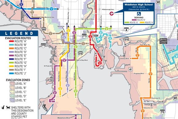
“We have evacuation routes identified and work with law enforcement,” says Preston Cook, Director of Hillsborough County Emergency Management.
Determining which specific roads would serve as designated evacuation routes depends on the threat level. “The storm track really determines the routes. Our evacuation zones are dedicated to getting people out of the [flood and storm surge] water.”
Getting people away from threatened areas, particularly along coastlines and low-lying areas, may require reversing lanes of traffic or using “contra flow” on the major roads and local highways. Making all lanes of South Dale Mabry Highway flow northbound to help evacuees escape low-lying South Tampa neighborhoods is one example that could be put into place, Preston says.
While many locals tend to flee out of town to destinations such as Orlando and Atlanta, Preston says it may make more sense to stay in local shelters or with family or friends closer to home.
“We tell those who are evacuating to go tens of miles, not hundreds of miles, but go as far as you need to go.”
Trying to travel long distances ahead of a storm can leave people stranded on the road without access to gasoline, drinking water, food and medical supplies.
Getting accurate information and proper messages out to local officials and to residents is a priority, Preston says, as his agency works with the Florida Department of Transportation (FDOT), first response teams and other local service providers.
“We do the best we can to avoid having to ask the governor for help,” Preston says. “Communication is the key.”
Those who are ordered to evacuate need to do so for their own good, he emphasizes.
“The government can only do so much,” he says. “We tell people who stay behind to prepare to be on their own for the first 72 hours [after a storm] because we may not be able to get to you.”
Downed power lines, flooded streets, fallen trees and many other hazards can prevent first responders from getting to those trapped in their homes or otherwise in need of assistance. “It’s up to you to be prepared, because it may not be safe for first responders to respond right away.”
New highway evacuation routes
Many new transportation arteries have been constructed since Hurricane Charley’s brush with the Tampa Bay Area more than a decade ago. These new roadways include State Road 570, more widely known as the Polk Parkway. This 24-mile limited-access toll road runs through Polk County near Lakeland and serves as an alternative route to U.S. 27 and Interstate 4. Segments of the Parkway have been expanded from two lanes to four over the past few years.
The Polk Parkway and other toll roads such as the Selmon Crosstown connecting downtown Tampa to Brandon, the Veterans Expressway in northwest Hillsborough County and the Suncoast Parkway, which extends from northwestern Hillsborough County to U.S. 98 near the northern Hernando County line, are integral parts of the Tampa Bay Area’s evacuation route network.
“We do have plans to ‘contra flow’ the Selmon Expressway in case of a hurricane – and of course suspend the tolls. That order would come from the Governor and then we would work with the County [Hillsborough] and City [Tampa], which have plans as well,” says Sue Chrzan, communications director with the Tampa-Hillsborough Expressway Authority, in giving an example of how the Selmon Expressway might be used under an evacuation order.
However, not all toll roads would be treated the same. According to Christa Deason, FDOT Public Information Officer, “the Veterans and Suncoast [toll corridor] is an evacuation route and, as such, upon order of the state emergency management office, tolls would be suspended. It is not, however, the main route out and there are no plans to run a contraflow operation on this roadway.”
Building new highways that could serve as evacuation routes in Florida is an ongoing process and largely the responsibility of FDOT. Funding, environmental impacts and neighborhood sentiment are among the factors that go into decisions about which roads to expand, how and when.
Parts of I-275 and I-4 through Hillsborough County, U.S. 19 in Pinellas County and S.R. 54 and 56 in Pasco County are among those expanded in recent years. Sections of Interstate 75 from Hernando County through Pasco, Hillsborough, Manatee and Sarasota have also been widened.
Construction is now underway to enhance traffic flow on Gandy Boulevard (State Road 694) in Pinellas County. The elevated road project extends from Interstate 275 to just east of North Fourth Street and includes new frontage roads and overpasses at 94th Avenue, Martin Luther King Jr. Street North, and in the Roosevelt Boulevard and 4th Street North area. The $83 million project is designed to help residents living in coastal areas of southern Pinellas County reach higher ground during an evacuation.
“Essentially all state roads are hurricane routes,” says FDOT spokesperson Kristen Carson.
How to evacuate if you don’t have a car
While most households in the Tampa Bay Area have a car, many don’t, which means people who rely on mass transit will likely be taking a bus to an evacuation shelter or another high-and-dry location.
Key to having access to bus transportation during a hurricane threat is early decision-making. Once a storm reaches winds of 39 mph or higher, the buses can no longer operate safely.
“To minimize the inconvenience to our customers, we will announce the need to interrupt service as early in the day as possible and will work to restore service just as soon as it is safe to do so,” says Sandra Morrison, Public Information Officer with HART {Hillsborough Area Regional Transit).
“HART keeps the local media updated about the status of service, so tune in to your TV and radio stations for the most-up-to-date information.” You can also keep up to date with information on the HART website.
HART also offers a free, last-resort emergency evacuation service for those who have no other options for getting to safety.
“The free service operates 10 routes to various shelters throughout [Hillsborough] County and is designed to move those in low-lying areas to higher ground,” says Morrison. There are specific stops along each evacuation route, which are marked with Emergency Shelter Bus Stop signs that are colored blue and white. Residents may also stand at a corner anywhere along the route and can wave down a bus as it approaches.
“Evacuation bus routes will begin after the Hillsborough County Emergency Operations Center instructs HART to do so and public shelters have opened. For the safety of our bus operators, evacuation buses will operate during daylight hours only and service will be suspended when the emergency operations center advises HART to remove vehicles from the road,” Morrison says.
The Hillsborough County School District will operate school buses to evacuate people in areas not covered by the 10 HART evacuation routes.
“In addition, residents may ask the driver to stop at any time along the fixed [emergency evacuation] route to evacuate to a destination other than the designated Red Cross shelter,’’ says Morrison. All HART buses are ADA accessible and can accommodate a maximum of two wheelchairs at any time.
Individuals who want to learn more about the free evacuation routes and those who have medical conditions that require additional assistance should call Hillsborough County Emergency Management at 813-272-6900.
A similar plan for making buses accessible during storms exists in Pinellas County, where nearly all shelters are located along current bus routes.
“When an evacuation is declared that involves shelters not on a current route, detours will be implemented immediately to serve those shelters, and staff will be positioned at terminals and transfer centers to provide information and help guide people to their nearest shelter, ” says Bob Lasher, External Affairs Officer at the Pinellas Suncoast Transit Authority (PSTA).
PSTA will list route changes on its website as well as within its social media channels on Twitter, Facebook and Instagram (@ridepsta). Residents can also find route updates on the PSTA InfoLine at 727-540-1900 and on the Pinellas County Emergency Management website.
PSTA bus service is also free during evacuations. “Once an evacuation has been ordered, PSTA waives fares and everyone rides at no charge to encourage people to get to the hurricane shelters,” Lasher says. “Even residents of non-member PSTA municipalities (such as Belleair Beach and Belleair Shore), will be picked up if they are on the road and flag down a bus.”
Individuals with special needs and those with disabilities are encouraged to register with their local fire departments in advance of a storm to arrange for dedicated evacuation transport.
Author

Related Articles

Darryl Shaw plans mixed-use project in East Ybor
For his next project, the Ybor City developer turns his attention east.

Saddlebrook’s transformation signals new chapter for fast-growing Wesley Chapel
Saddlebrook’s ambitious renovation project strengthens local economy, preserves sense of place.

Take a Tampa adventure with local artist Mishou Sanchez
The local artists’s coloring book, “Poppi Pink’s Tampa Adventure,” explores the city through a pop-surreal lens.